
 JOYNEXT Technology Co., Ltd.
News Center

JOYNEXT Presents Vehicle Positioning System with Lane-level Accuracy
Available in Europe and the USA soon
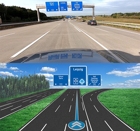
DRESDEN, November 4, 2020 —— JOYNEXT GmbH is launching a vehicle positioning system with lane-level accuracy. It uses satellite data (GPS) combined with lane information collected from an additional camera in the vehicle. This data is synchronized continuously with high-precision (HD) map data. A tracking algorithm also constantly monitors, assesses and checks the determined vehicle position for plausibility.
The lane-level positioning system will now be deployed in the vehicles of a renowned German automotive group. That makes JOYNEXT one of the first vendors to bring this function to market with a volume manufacturer.
Initially, the system will help drivers navigate interstate highways and highway interchanges. It can be updated online, and will be upgraded successively whenever more HD map data is available. State highways will also be included soon. The aim is to offer lane-level precision vehicle positioning on all roads – even including urban roads. However, suitable map material must be made available first.
New system helps drivers deal with mixed driving situations
“We developed the system based on a customer request,” reports Uwe de Nardi, R&D Director at JOYNEXT GmbH. “It supplements GPS with additional information, allowing far more accurate positioning.” The new system uses a camera that has already proven itself in lane detection and lane-keeping applications.
To test the system, JOYNEXT’s experts have driven miles and miles in the past few months. “We tested it thoroughly and found that lane-level positioning really makes life easier in complex driving situations,” explains Uwe de Nardi.
Other applications for ADAS
In addition to the map material, the acoustic signals were also adapted to the improved data. This gives users more detailed directions and shows them exactly where the vehicle is located on the display through a moving, flowing representation of the road. JOYNEXT’s lane-level positioning will initially be launched in Europe and the USA. Asia will follow a little later as soon as map data of sufficient quality is available.
“We will continue to adapt and improve the system. For example, we aim to include construction site detection to avoid incorrect directions in these situations,” adds Stavros Mitrakis, CEO at JOYNEXT GmbH, describing the outlook. “The system will also incorporate additional information like guardrails, to strengthen the connection to the real world.” As a networked vehicle technologies specialist, JOYNEXT naturally has this aspect in mind for its new development:This positioning module will also be available for various ADAS applications in future vehicles by integrating it in the vehicle’s electronic horizon, helping achieve (semi-)autonomous driving.


 ZG Anbei No. 3302090200350 zicp Bei No. 2020035182-1